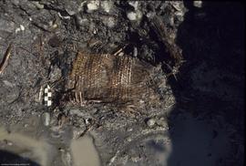
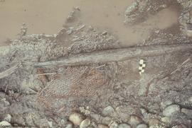
Artifact #10675 in situ - unit M9 from south
- LoAA 9.1-3-24-61
- Item
- August 21, 1974
This item is an image showing a basket in situ with scale.
999 resultados com objetos digitais Mostrar resultados com objetos digitais
Artifact #10675 in situ - unit M9 from south
This item is an image showing a basket in situ with scale.
Artifact #10677 in situ - unit M9 from south
This item is an image showing part of a basket in situ with scale.
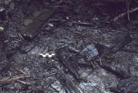
Artifact #10743 (canoe bailer) in situ - unit M9 from west
This item is an image showing an artifact identified as a canoe bailer in situ with scale.
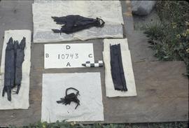
This item is an image showing 4 parts of an artifact after they have been excavated. Comment on the slide casing identifies this as a canoe bailer.
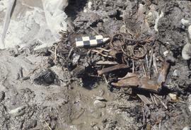
Artifacts #10689 (weir stake) and #10690 (basket)
This image shows two artifacts in situ with scale. Image is from Roll D of 1974.
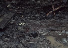
This image shows basketry in situ with scale. Image taken on roll D of 1974.
Figure 9 - Musqueam Northeast (DhRt-4) - west face of pits K9 and K10
Map is a profile drawing showing the layers with a key that indicates the different types of loam and the location of rocks.
Map 2 DhRt-4 Musqueam North East
Map is a topographic map of Musqueam North East showing the areas that were excavated in 1972 and 1973. The contour intervals on this map are 0.2 meters. There are errors in the year designations on the drawing: often shown as 1973 when field re...
This map is a topographic map showing the areas excavated in 1972 and 1973. The contour interval is 0.2 meters. Map also shows the location of the mortuary houses.
Figure 1 - Musqueam Northeast Locality
This map is a topographic map showing the locations of DhRt-2, and DhRt-4. Map contour interval is 5 feet.
DhRt 4: Profile of south face at south 4 metres from east 10-12 metres
This map shows a profile drawing. Detailed legend to the right of the map.
DjRi-5: Profile of Inner Lip of Pithouse #1 at S25' looking north
Parte de Aseláw (Esilao Village) Site - DjRi-5 Project fonds
This item is a profile drawing showing seven feet of the inner lip of pit house 1.
DjRi-5: Contours of Area Adjacent to Pit House #1, from 0-S45', 0-E40'
Parte de Aseláw (Esilao Village) Site - DjRi-5 Project fonds
This item is a topographic map showing contour lines at 1 foot intervals.
DjRi-5: Profile of W10 Face from S25' to 60'
Parte de Aseláw (Esilao Village) Site - DjRi-5 Project fonds
This item is a profile drawing. It includes three other profiles which have been copied in order to show them connected. This map shows the locations of pit houses, unexcavated areas, and the stratigraphy of the layers.
Profile of W15 Face from S25' to S60'
Parte de Aseláw (Esilao Village) Site - DjRi-5 Project fonds
This item is a profile drawing. One section of this map was been copied from the field notes. The map shows the location of charcoal samples and the stratigraphy of the layers.
Parte de Aseláw (Esilao Village) Site - DjRi-5 Project fonds
This item is a profile drawing. The map shows the location of charcoal samples and the stratigraphy of the layers. Carbon samples UBC No. 19, 20, and 21 are mentioned.
DjRi 5: Post-mould Plan of Recent Historical Surface Features Adjacent to Pit
Parte de Aseláw (Esilao Village) Site - DjRi-5 Project fonds
This item is a plan drawing. The map is a plan of structures numbered 1-4 showing the location and size of the post-moulds.
Parte de Aseláw (Esilao Village) Site - DjRi-5 Project fonds
This item is a profile drawing. This map shows the profile of S0-25' looking west. Roots, rocks, post-moulds, and the stratigraphy are all shown.
DjRi 5: Profile from S5' to S25 at W10
Parte de Aseláw (Esilao Village) Site - DjRi-5 Project fonds
This item is a profile drawing. It is a compilation of profiles drawn in the field.
Profile of S25 face from W15 to W40
Parte de Aseláw (Esilao Village) Site - DjRi-5 Project fonds
This item is a profile drawing. It shows where soil samples had been taken and the locations of concentrations of fire-cracked rock.