- 05.1-4-I40
- Item
- 1955
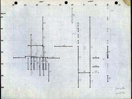
This item is a hand drawn plan on graph paper of the house floor showing soil types and the location of post holes.
This item is a hand drawn plan on graph paper of the house floor showing soil types and the location of post holes.
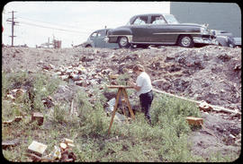
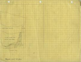
Image shows C. Westphal surveying at the Marpole site.

Ma 1955 Description of fragments
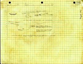
This paper includes two outlines of harpoon points, along with information on stratigraphy. The description also makes note of various fragments and their corresponding coordinates.
Marpole floor plans and profiles S100'-170'-W100'-60'
This map shows what appears to be multiple numbered profiles. The floor plan was drawn on two separate sheets of graph paper, and glue remnants on each indicate they were previously glued together.
Marpole profiles S70'-130'-E0'-40'
This map shows what appears to be multiple numbered profiles. The floor plan was drawn on two separate sheets of graph paper, and glue remnants on each indicate they were previously glued together.
Marpole profiles S100'-S170'-W150'-110'
This map shows what appears to be multiple numbered profiles. The floor plan was drawn on two separate sheets of graph paper, and glue remnants on each indicate they were previously glued together.
Marpole profiles S100'-160'-W150'-60'
This map shows what appears to be multiple numbered profiles.
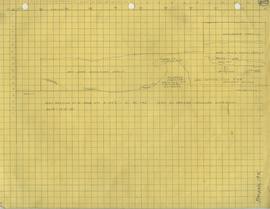
Cross section of North face S42'6"-W77'6"-83'5"
This profile is a detailed stratigraphy noting the approximate location of a house floor deposit and fire cracked rocked.

Marpole profiles S70'-130'-W40'-E50'
This map shows what appears to be multiple numbered profiles. Numbers written may refer to numbers also written on profile drawings in this file.

Marpole floor plans S100'-160'-W150'-60'
This floor plan shows multiple squared off areas, possibly excavation units.


This item is a folded paper with sets of survey points written on one side and a grade percentages for a class on the opposite site.
This item consists of 5 stapled pages which lists survey points, some crossed out. The notes are made on the back of unused UBC examination booklets. Contact LOA Archivist to view.

This is a photocopy of Map No. 3 from LOAA 5.1/04/I01, Poster of maps. It shows a city lot plan, SW Marine and Granville.
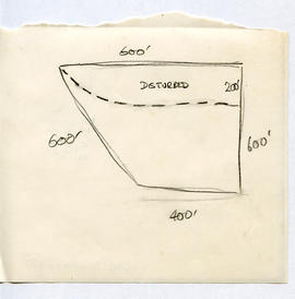
Plan view showing disturbed area and dimensions.
Cross-section of N. face at S147'6"-W85-95'
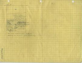
Profile is a detailed stratigraphy of a gravel feature at the site.
Profile shows detailed stratigraphy of site.
Profile shows detailed stratigraphy of the site.

Cross section of N face of Section S135'-137'6"-W77'6"-83'
Profile shows detailed stratigraphy of the site.

Profile of East Face at W70' S120'-129'
Profile shows detailed stratigraphy of the site.