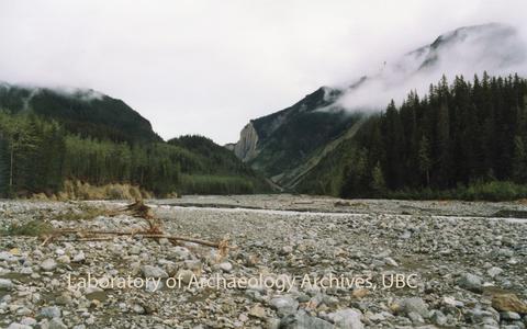
Title and statement of responsibility area
Title proper
Iskut Mine Access Road Project fonds
General material designation
- Textual record
- Graphic material
Parallel title
Other title information
Title statements of responsibility
Title notes
- Source of title proper: Title is based on the name of the archaeological project.
- Statements of responsibility: The principal investigator for this project was ARCAS Consulting Archaeologists Ltd.
Level of description
Fonds
Reference code
LoAA38
Edition area
Edition statement
Edition statement of responsibility
Class of material specific details area
Statement of scale (cartographic)
Statement of projection (cartographic)
Statement of coordinates (cartographic)
Statement of scale (architectural)
Issuing jurisdiction and denomination (philatelic)
Dates of creation area
Date(s)
-
1990-1991 (Creation)
- Creator
- ARCAS Consulting Archaeologists Ltd.
Physical description area
Physical description
9.3 cm of textual records.
102 photographs : col. ; 10 x 15 cm.
30 photographs : col. acetate negatives.
102 photographs : col. ; 10 x 15 cm.
30 photographs : col. acetate negatives.
Publisher's series area
Title proper of publisher's series
Parallel titles of publisher's series
Other title information of publisher's series
Statement of responsibility relating to publisher's series
Numbering within publisher's series
Note on publisher's series
Archival description area
Name of creator
Custodial history
Documentary material, including both textual and photographic records, were transferred to the custody of the Lab of Archaeology from ARCAS following the conclusion of the project. In 2011, the collection was re-housed in the current LOA archives location (room 221A at MOA). In November 2023, the collection was accessioned into the LOA archives.
Scope and content
This fonds consists of textual and photographic records related to the Iskut Mine Access Road Project conducted by ARCAS starting in 1990 under HCA permit 1990-0102, which include archaeological sites HeTq-1 and HcTp-1. Textual records include correspondence, notes from community meetings, field notes, a photo record, and reports. Photographic material includes negatives and print photographs. Included in Series 2 are the original envelopes that the developed photographs came in, which have the dates that the photographic material was processed. The Heritage Site Overview Assessment Report contains information about the archaeological overview assessment conducted as well as the findings and conclusions of the project. Digitized material can be found on the LOA archives server in the digital fonds folder.
This fonds consists of 1 box and has been arranged into 3 series:
Series 1 – Photographic Material
Series 2 – Correspondence and Notes
Series 3 – Reports
This fonds consists of 1 box and has been arranged into 3 series:
Series 1 – Photographic Material
Series 2 – Correspondence and Notes
Series 3 – Reports
Notes area
Physical condition
Physical condition and preservation information can be found on the series level.
Immediate source of acquisition
Arrangement
Language of material
Script of material
Location of originals
Availability of other formats
Some records have been digitized.
Restrictions on access
Some materials may be restricted due to private information. Contact the LOA Archivist for further information.
Terms governing use, reproduction, and publication
Under Copyright. Permission must be obtained from rights holder prior to reproduction or publication.
Finding aids
File list is available.
Associated materials
Accruals
No new accruals are expected at this time.
Alternative identifier(s)
Heritage Conservation Act Permit
1990-0102.
Standard number area
Standard number
Access points
Subject access points
Place access points
- Iskut River Valley, British Columbia
- Łuwechōn [Iskut, B.C]
- Jennifer Creek, British Columbia
- Eskay Mine Camp, British Columbia
- BCM Drill Camp, British Columbia
- Klappan River Drainage, British Columbia
- Ningunsaw River, British Columbia
- Bill Creek, British Columbia
- Volcano Creek, British Columbia
- Iskut River, British Columbia
- Iskut River Canyon, British Columbia
- Bob Quinn Camp, British Columbia
- Hoodoo Mountain, British Columbia
- Borden Site Number » HeTq-1
- Borden Site Number » HcTp-1
- Iskut-Unuk Divide, British Columbia
- Snippaker Creek, British Columbia
Name access points
- ARCAS Consulting Archaeologists Ltd. (Creator)
Genre access points
Control area
Description record identifier
Institution identifier
Rules or conventions
Status
Final
Level of detail
Full
Language of description
Script of description
Digital object metadata
Filename
LoAA38_S1_F2_i15_1990_Hoodoo-R-Valley.jpeg
Media type
Image
Mime-type
image/jpeg
Filesize
253.8 KiB
Uploaded
June 19, 2024 10:53 AM
