Title and statement of responsibility area
Titel
Lions Gate Crossing Project fonds
Algemene aanduiding van het materiaal
- Textual record
- Graphic material
- Cartographic material
Parallelle titel
Overige titelinformatie
Title statements of responsibility
Titel aantekeningen
- Source of title proper: Title is based on the contents of the fonds.
- Parallel titles and other title information: Was formerly called Stanley Park Project fonds.
- Statements of responsibility: The principal investigator for this project was Sheila J. Minnie
Beschrijvingsniveau
Archief
referentie code
LoAA37
Editie
Editie
Edition statement of responsibility
Class of material specific details area
Statement of scale (cartographic)
Statement of projection (cartographic)
Statement of coordinates (cartographic)
Statement of scale (architectural)
Issuing jurisdiction and denomination (philatelic)
Datering archiefvorming
Datum(s)
-
1963 - 2000, predominant 1994-1995 (Vervaardig)
- Archiefvormer
- Sheila J. Minni
Fysieke beschrijving
Fysieke beschrijving
5.4 cm of textual records.
34 photographs : b&w ; 10 x 15cm
22 Photographs : b&w ; acetate negatives.
24 maps.
34 photographs : b&w ; 10 x 15cm
22 Photographs : b&w ; acetate negatives.
24 maps.
Publisher's series area
Title proper of publisher's series
Parallel titles of publisher's series
Other title information of publisher's series
Statement of responsibility relating to publisher's series
Numbering within publisher's series
Note on publisher's series
Archivistische beschrijving
Naam van de archiefvormer
Biografie
Geschiedenis beheer
The UBC Laboratory of Archaeology received materials and records related to the Lions Gate Crossing Project in December 1997 from Sheila Minni. These records have been in the custody of the Lab of Archaeology since the deposit was made in late 1997. In 2011, the collection was re-housed in the current LOA archives location (room 221A at MOA).
Bereik en inhoud
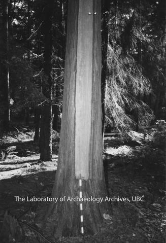
The Lions Gate Crossing Project fonds contains all of the records related to the archaeological activity that took place in the Stanley Park area during the 1994 survey and excavations that were conducted on the behalf of the BC Ministry of Highways. This fonds also includes correspondence between Sheila Minni and LOA staff about the deposit of these materials in the late 1990s. Photographs of crew are included in these fonds as well as many photographs of culturally modified trees and structures in
Stanley Park.
This fonds consists of 1 box containing series 1-6, with series 5 being stored in the oversize storage/map cabinet in drawer 45. Series 6 consists of the final report in which a digital copy (PDF) is available only and is located on the archive’s server. Series 1 consists of surface observation records organized into one file. Series 2 consists of test excavation records organized into 2 files. Series 3 consists of photographic material, including print photographs, negatives, and photo records which have been organized into 2 files. Series 4 consists of notes and correspondence related to the project, organized into 2 files. Series 5 consists of 24 maps of various places across Stanley Park and the area that would be affected by the causeway expansion. This series is housed in the oversize storage/map cabinet in drawer 45.
This fonds consists of 6 series:
1. Surface Observation Records
2. Test Excavation Records
3. Photographic Material
4. Notes and Correspondence
5. Maps
6. Reports
Aantekeningen
Materiële staat
Physical condition is noted on the series and file levels in this fonds.
Directe bron van verwerving
Ordening
In 2023, the collection was rearranged and described to better reflect the project history. The fonds was renamed from “Stanley Park” to “Lions Gate Crossing Project” to better reflect its contents and the title of the archaeological project, with unrelated material being removed.
Taal van het materiaal
Schrift van het materiaal
Plaats van originelen
Beschikbaarheid in andere opslagformaten
TIFF and PDF.
Restrictions on access
Some materials from this fonds may be restricted and cannot be accessed without permission from the appropriate First Nation(s).
Termen voor gebruik, reproductie en publicatie.
Under Copyright. Permission must be obtained from rights holder prior to reproduction or publication.
Toegangen
File list is available.
Associated materials
Aanvullingen
No new accruals are expected.
Culturally sensitive note
Some material in this fonds contains culturally sensitive material.
Alternative identifier(s)
Heritage Conservation Act Permit
Black Volumes Index
Standard number area
Standaard nummer
Trefwoorden
Geografische trefwoorden
Naam ontsluitingsterm
- Sheila J. Minni (Archiefvormer)
Genre access points
Beheer
Identificatie van het beschrijvingsrecord
Identificatiecode van de instelling
Regels of conventies
Status
Finale
Niveau van detaillering
Taal van de beschrijving
Schrift van de beschrijving
Digitaal object metadata
Bestandsnaam
LoAA37-S1-F1-i7_Atom2.jpg
mediatype
Afbeelding
Mime-type
image/jpeg
Bestandsgrootte
446.3 KiB
ingelezen
25 juni 2024 08:35
